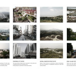
Territory condition
The site is located in the northwest of the New Territories in Hong Kong. This place is adjacent to the deep Shenzhen Bay. It is reclaimed land that used to be marshland, wetland and ponds.
Before the year 1990, the local inhabitants lived mainly on agriculture and aquaculture production. This place is also the main pond fish and oyster production in Hong Kong.
The Tin-Shui Wai community was constructed in the late 1990s. This extremely dense town was initiated by the Hong Kong government and contains apartments for 300,000 low-income people. This place has to confront the crucial problems bringing by the fast urbanization processes to the northwest of New Territories. So far, there is still a larger demand for residential areas around that place.
Another sign of centralization is the development of Yuen-Long town, which was established initially as a market town in order to serve the surrounding villages for the exchange of rural produce. Recently, it became a modern city center after the completion of Tin-Shui Wai community. The infrastucture for the regional transportation, such as expressway, LRT and local tram system is also covering most places within the city.
Generally, the conflict between the urbanization processes in the two metropolis and the existing rural condition would be especially taken account within this project. And departing from the concept of ruralization, alternative urban modes have been extabished according to the branching city project.
Research questions:
How can we balance urban development with existing rural activities based on the natural environment?
What types of buildings could become part of the branching structure by considering rural characteristics?
What specific tension within the territory drives regional development?
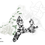
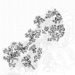
By fully respecting the territorial conditions such as topography and rural characteristics, an infrastructure-based network is generated, starting from the transit nodes as the articulation from the city center to the site. The network also sprawls into the sea at some of the coastal area to create diverse building types which can adapt the various public functions.
By using the hierarchical branching structure, the property of rural activities is maintained according to the semi-connected character of the branching structure itself. Meanwhile, the specific quality of rural and nature space could be properly preserved between the structure segments.
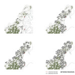
Three-level branches
The primary branch is considered as the main road system of the territory, and the buildings could be deployed on the secondary and third branches. The secondary branch, which directly connects to the primary road, represents the identity of collectivity, whereas the third branch refers more to the property of individuality. However, the hierarchy exists not only explicitly in the different levels of the holistic branch structure itself, but also implicitly, parallel within each level.
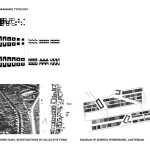
This distinction could be further addressed by the building typologies. Two case studies are brought into this project, the Japanese linear village mode and the planning strategy of Borneo Sporenburg in Amsterdam. The former represents the logic within rural activities such as the relationship between working and living, as well as the specific spatial organization. The latter offers a solution to the urban housing, and the mixture style of collective types and individual types.
Spatial transformation
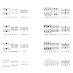
In order to programmatically organize the branch hierarchy as well as the gradient characteristics of building typology, the catalogue of floor plans shows the possibility of putting various building functions into these building types.
Generally, the public activities, such as the parking area, working space, leisure place and collective living space, will be arranged in the secondary level branches. Individual housing units, both the rural type and urban type, will be organized alongside the third level branches.
The variation of building types mainly relates to the created open public space. For those groups which are close to the primary roads represent a collective identity will have larger open public areas, the linear gradient happens by the shrinking area of public space. When the open public space becomes semi-open, inside the courtyard for instance, the building type changes completely, and represents some sort of privacy. Different building types are applied to the branching structure, and the hierarchy among this typology is as explicit as the level of secondary and third branches.
The gradient change of the public space created by building types is also clear that when it goes deeper into the territory, the public space will get smaller. The building changes to a closed type with inside courtyard and finally into a solid style. Consequently, the identity of these variations also express a gradient tendency from public to private.
For the individual part, by reference to the linear village, buildings of the rural type would generally be organized alongside the streets. Each plot has a large area backyard, aiming to support the rural activities such as mini farming. Because the rural type always appears close to existing villages, so they get connected directly by pedestrians.
The urban type of individual housing is based on the idea of concentration. Building clusters assemble around each intersection point on the third branches and shape the spatial quality similar to the low-density residential area within the city, and these proximity clusters also have the possibility to be integrated into a bigger community.
Branching City
By taking the view from a macro scale, in order to better address the primary issue which influences the regional development, the infrastructure-based branching network is generated from the territorial patterns and has the ability to balance the pressure from urban sites and the confrontation from the rural sites.
In order to combine dense interventions with a more nuanced urban approach, the spatial networks are then transformed into building entities with the capacity to “fine tune” the deployment of architectural and landscape elements through flexible design mechanisms.
Landscape also plays an important part in this project. The initial intention of getting the space in-between the branches would be further elaborated by a landscape strategy. Large mountain areas will be isolated and preserved as its natural characteristics. Smaller empty spaces could be converted into artificial green land inside the branching city.
By overlapping with the territory map, comparing to the existing city fabric, the branching city expresses an alternative approach to the sub-urbanization of the rural area. The idealistic strategy offers a dissolvable mode that emerges from the territorial patterns and characters. It is a form of urban utopia that is antithetical to the overwhelming development of urbanism.